Short answer: the best hiking trails Malta offers are short by mountain standards but big on views: the Dingli Cliffs on the west coast, the Victoria Lines fortifications across the middle of the island (about 12 km end to end), the coast from Għajn Tuffieħa and Golden Bay to Ġnejna (about 6 km), the Majjistral Nature and History Park in the north, and the countryside walks around Mdina, Baħrija, Mellieħa, Marsaxlokk and Qrendi that VisitMalta promotes. Add Comino and Gozo’s Dwejra coast for a day trip. Walking is free; you pay only for the bus (€2.00 a single in winter). The season is October to May: summer is too hot for most routes.
Below are 12 walks as plan cards, with approximate distance, time, difficulty, where they start and finish, how to get there and when to go. Distances are approximate: most Maltese routes have several variations, and the figures come from park and tourism sources or published route maps. Always check the route on a map before you set off.
An honest expectation-setter: Malta isn’t wilderness. Many walks pass farms, quarries, roads and the odd building site, and paths aren’t always signposted. That’s part of the character. The reward is that you’re never more than an hour or so from a village, a bus stop or a café, which makes walking here very easy to fit into a morning with friends.
Malta’s walks at a glance
Last checked October 2026. “Distance” is approximate; “Time” is walking time at an easy pace with stops.
| Walk | Distance | Time | Difficulty | Start / end |
|---|---|---|---|---|
| Dingli Cliffs and Fawwara | About 8 km loop (longer if you continue to Wied iż-Żurrieq) | 2.5–3 hours | Easy to moderate | Dingli village / cliffs |
| Victoria Lines | About 12 km end to end, often walked in sections | A half day for a section, a full day for all of it | Moderate, some steep stretches | Fomm ir-Riħ side to Madliena side |
| Golden Bay to Ġnejna | About 6 km | 2 hours | Moderate | Golden Bay / Ġnejna Bay |
| Majjistral Park coast | The park’s coastal stretch is about 6 km, Anchor Bay to Golden Bay | 2–3 hours | Moderate | Anchor Bay area / Golden Bay |
| Mdina Walk | Short countryside loop | 1.5–2 hours | Easy | Mdina / Rabat |
| Baħrija Walk | Countryside loop | 2 hours | Easy to moderate | Baħrija village |
| Watch Towers Walk | Countryside and coast | 2 hours | Easy to moderate | Outskirts of Mellieħa |
| Tas-Silġ Walk | Countryside loop | 1.5–2 hours | Easy | Marsaxlokk / Żejtun |
| Ħal Millieri Walk | Countryside loop | 1.5–2 hours | Easy | Żurrieq / Mqabba |
| Tal-Maqluba Walk | Short loop | 1–1.5 hours | Easy | Qrendi |
| Comino | Island loop on footpaths | 2–3 hours | Easy to moderate, no shade | Blue Lagoon jetty |
| Dwejra, Gozo | Coastal paths around the bay | 1–2 hours | Easy to moderate, cliff edges | Dwejra, San Lawrenz |
Sources: VisitMalta walks (Malta Goes Rural routes), Majjistral Park and published route maps. Cost for all: free, apart from transport.
The walks
1. Dingli Cliffs and Fawwara
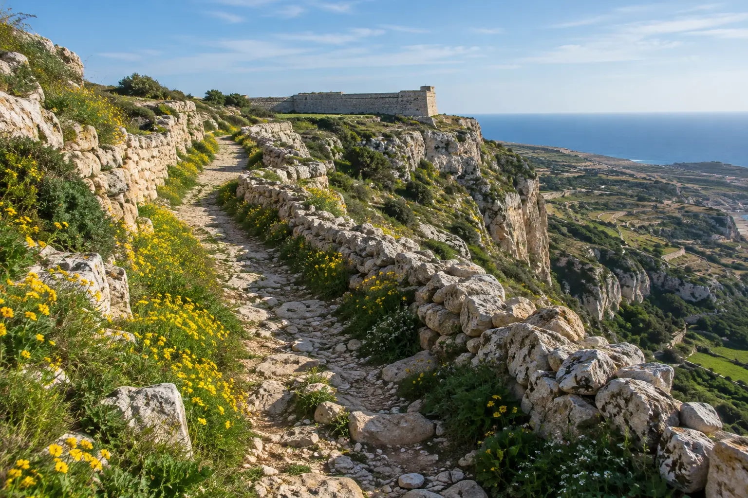
- What: the highest stretch of Malta’s coastline, with fields running right to the edge, a small chapel, and views to the islet of Filfla. The VisitMalta Dingli–Fawwara–Wied iż-Żurrieq walk continues along the coast for a longer day.
- Getting there: bus to Dingli, then walk to the cliff road.
- Best season: October to May; sunset all year.
- Who pays: free; split a taxi back if you finish somewhere without a bus.
2. The Victoria Lines
- What: a 19th-century British line of fortifications along a ridge that crosses the island, roughly 12 km from coast to coast. You get big views over the north, old forts and some steep ups and downs.
- Getting there: walk a section: buses run to towns along the ridge, such as Mġarr, Mosta and Naxxar. Check the route in the tallinja app.
- Best season: autumn to spring. Some parts are rough, so wear proper shoes.
- Who pays: free.

3. Golden Bay to Ġnejna
- What: a coastal walk of about 6 km from Golden Bay past Għajn Tuffieħa and over the headland to Ġnejna Bay, with clay slopes and big sea views.
- Getting there: buses to Golden Bay; Ġnejna has fewer buses, so plan the return.
- Best season: October to May.
- Who pays: free; bring a picnic.
4. Majjistral Nature and History Park
- What: Malta’s first national park, covering about 6 km of coastline from Anchor Bay to Golden Bay and inland. Cliffs, garigue and old military sites, with marked paths.
- Getting there: buses towards Mellieħa or Golden Bay; check the park’s site for access points.
- Best season: autumn to spring.
- Who pays: free.

5–10. The Malta Goes Rural walks
VisitMalta promotes a set of countryside walks created under the Malta Goes Rural project, each with a downloadable brochure. They’re shorter and gentler than the coastal hikes, and good for a relaxed group walk with history along the way:
- Mdina Walk: countryside and sights around the old capital. Bus to Rabat/Mdina.
- Baħrija Walk: the rural west, around the village of Baħrija. Car or limited buses.
- Watch Towers Walk: the outskirts of Mellieħa and old coastal towers built against pirates. Bus to Mellieħa.
- Tas-Silġ Walk: the outskirts of Marsaxlokk and Żejtun, with fortifications and religious buildings. Bus to Marsaxlokk.
- Ħal Millieri Walk: the countryside between Żurrieq and Mqabba. Bus to Żurrieq.
- Tal-Maqluba Walk: around the Maqluba sinkhole near Qrendi. Bus to Qrendi.
11. Comino
- What: the small island between Malta and Gozo, best known for the Blue Lagoon. Walk away from the lagoon on the footpaths and you’ll have coves, a tower and views to both islands largely to yourselves outside summer.
- Getting there: boat from Ċirkewwa or Marfa (fares vary by operator).
- Best season: spring and autumn. There’s almost no shade.
- Who pays: pay your own boat ticket.
12. Dwejra, Gozo
- What: the dramatic bay on Gozo’s west coast, with Fungus Rock, the Inland Sea and fossil-filled rocks. Combine it with a ferry day to Gozo.
- Getting there: Gozo Channel ferry (€4.65 standard foot-passenger fare, validated in Gozo on the return), then a bus towards San Lawrenz.
- Best season: autumn to spring; stay well back from cliff edges.
- Who pays: pay your own ferry; split a taxi on Gozo if buses don’t fit.

Which walk for which group?
Total beginners or a mixed group
Pick one of the Malta Goes Rural walks (Mdina, Tas-Silġ or Tal-Maqluba). They’re short, mostly flat and close to a village, so there’s always a café and a bus at the end.
Fit friends who want a proper hike
A long section of the Victoria Lines, or Dingli Cliffs continued along the coast towards Wied iż-Żurrieq. Start early and plan the return bus or a shared taxi.
A walk with a swim
Golden Bay to Ġnejna in October or May, when the sea is still (or already) warm enough, or Comino in early autumn.
Visitors who want the views
Dingli Cliffs at sunset, or a Gozo day ending at Dwejra. Both give you the “wow” photos without a long hike.
The walking year in Malta
- October and November: the season opens. The ground is dry and dusty after summer, the first rain greens things up, and the light is soft.
- December to February: cool, clear days are perfect for longer walks; storms can make clay paths slippery, so check the forecast.
- March to May: the best months. Fields are green, wild flowers cover the cliffs, and the temperature is ideal. Book group walks early.
- June to September: too hot for most walks. If you must, start at dawn, stick to short coastal routes and finish with a swim.
Walking with a group
If you don’t want to plan the route yourself, join a group. The Ramblers’ Association of Malta organises about 50 walks a year and welcomes guests to try one; its October 2026 programme included Miżieb (18 October) and Żabbar and Cottonera (25 October). Group walks are also one of the best ways to meet people: see our guide to the Ramblers Association of Malta for walks and membership.
Hiking safely in Malta
- Heat: from June to September, walk only early in the morning, or not at all. There’s very little shade on most routes.
- Cliffs: many cliff edges have no railings, and the rock can crumble. Stay well back, especially in wind.
- Paths: rocky and uneven, even when “easy”. Wear proper shoes, not sandals.
- Hunting season: according to BirdLife Malta, the autumn hunting season runs from 1 September to 31 January each year, and there is also a short spring season. You may meet hunters in the countryside. Stick to public paths, be visible, and avoid private land. Under the 2025 rules, hunting wasn’t allowed after 13:00 on Sundays and public holidays, so those afternoons are quieter.
- Water and phone: bring more water than you think, a charged phone and a snack. Mobile coverage is generally good.
- Weather: autumn and winter storms can make cliff paths and clay slopes slippery. Postpone if it’s wet or very windy.
- Getting back: check the last bus from your finish point before you start. Rural routes can have long gaps between buses.
What to bring
- Shoes with grip, a hat, sunscreen and a light layer for the wind.
- At least a litre of water per person, more in warm months.
- Snacks or a picnic (most routes have no cafés).
- A charged phone with an offline map and the tallinja app.
- Cash for a coffee or a bus if you end up somewhere unexpected.
Group walk invite template
“Sunday walk: Golden Bay to Ġnejna, about 6 km, 2 hours. Meet at the Golden Bay bus stop at 09:30. It’s free; bring water, a snack and proper shoes. We’ll split a taxi back if the bus doesn’t fit. Who’s in?”
For more free plans, see free things to do in Malta; for a day further afield, the Gozo day trip itinerary; and for a walk as a date, date ideas Malta.
Frequently asked questions
What are the best hiking trails in Malta?
The Dingli Cliffs, the Victoria Lines, the Golden Bay to Ġnejna coast, the Majjistral Nature and History Park, and Gozo’s Dwejra coast are the classics. VisitMalta’s countryside walks around Mdina, Baħrija, Mellieħa, Marsaxlokk and Qrendi are gentler options.
When is the best time to hike in Malta?
October to May. Summer is too hot for most routes, with little shade. Spring brings wild flowers; winter brings clear, cool days but also occasional storms.
How long is the Victoria Lines walk?
About 12 km from coast to coast. Most people walk it in sections, which take a few hours each.
Is hiking in Malta free?
Yes. Walking the trails costs nothing. You pay only for transport: a single day-route bus ticket is €2.00 in winter and €2.50 in summer (Malta Public Transport, checked October 2026).
Are there hiking groups in Malta?
Yes. The Ramblers’ Association of Malta organises about 50 walks a year and welcomes guests to try one. Check its walks programme for dates and meeting points.
Is it safe to hike during hunting season?
Generally yes, if you stay on public paths and keep visible. BirdLife Malta says the autumn hunting season runs from 1 September to 31 January. Under the 2025 rules, hunting wasn’t permitted after 13:00 on Sundays and public holidays.
Make it a plan
A walk is the easiest group plan there is: free, outdoors, and easy to talk on. Pick a route, a Sunday and a meeting point, and send the invite.
Want to turn this into an actual plan? MeetNow is a free app for meeting people in person: a host posts a plan at a public place, says who pays (host pays, split, pay your own or free) and picks who joins. It is live in Malta now on the web, with the iPhone and Android apps coming to the App Store and Google Play soon: open MeetNow and see this week’s plans in Valletta, Sliema and St Julian’s.
We may mention products we’re connected to. Read our affiliate and product disclosure.